Information Source: National Weather Services
3 p.m. Weather Update
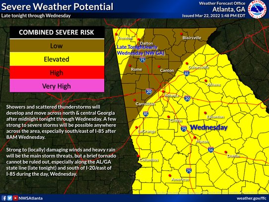
Overview (Tonight-early Wednesday AM): Severe thunderstorms developing over parts of Mississippi and western Alabama this afternoon/early evening, are expected to weaken as they approach Georgia later this evening and overnight.
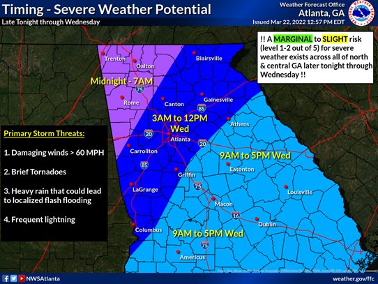
Despite this overall weakening trend, parts of northwest and west-central Georgia could still see a few strong to severe storms overnight, capable of damaging winds and heavy rainfall. A brief tornado is a very low possibility, as well.
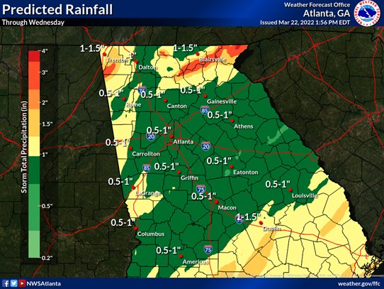
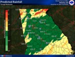
An elevated Flood/Flash Flood risk across parts of northwest Georgia as 1 to 2 inches of rain falls within a 6-9 hour period. Locally higher amounts will be possible
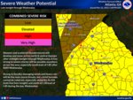
Outlook for Wednesday: Ongoing showers and scattered thunderstorms will continue tracking east across the area. The severe threat is expected to ramp up through the morning hours as daytime heating generates enough instability to support a few strong to severe storms, mainly south/east of I-85 after 10AM. This area is under a SLIGHT RISK for severe weather (from SPC).
When will conditions improve (i.e. severe threat ends) across the area?
NW Georgia between 7-10AM Wed
I-85 corridor (including ATL metro) between 9A-12P (noon)
Remainder of central GA / exiting the forecast area between 3P-7P Wed afternoon/evening
GRAPHIC TAGS FOR ATTACHED IMAGES
IMAGE ONE: TIMING FOR A FEW STRONG TO SEVERE STORMS (LATE TONIGHT THROUGH WEDNESDAY)
IMAGE TWO: SEVERE RISK AREAS **DAMAGING WINDS BEING THE PRIMARY STORM THREAT**
IMAGE THREE: STORM TOTAL RAINFALL: 1/2 TO 2" OF RAIN CAN BE EXPECTED WITH LOCALLY HIGHER AMOUNTS POSSIBLE. MUCH OF THIS RAIN WILL OCCUR IN A 6-HOUR WINDOW, WHICH WILL ELEVATE THE RISK FOR RIVER/STREAM FLOODING AND/OR LOCALIZED FLASH FLOODING
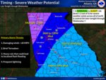
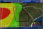
IMAGE FOUR: AREAS IN GREEN AND YELLOW HAVE THE BEST CHANCE TO SEE RIVER/STREAM FLOODING AND LOCALIZED FLASH FLOODING